Tag Archives: FST II

FST II : Day Ten – Home

Cold, cold, cold this morning. And again, watching the weather, we realized that we were only about 100 miles ahead of the storm. Needless to say, we got on our horse early, and started driving before sunrise.

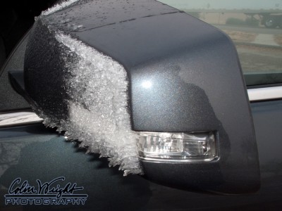
The farther east we got, the foggier it got. And the temperature continued dropping, well below freezing. It was then that I looked at my side mirror, and saw the ice.

The fog was freezing to the Acadia as we plowed ahead. The roads felt ok, so I continued driving, knowing what lay behind us. The sun came up, the temps warmed, and the ice began falling off the car, all of which was good news.

The rest of the way was pretty uneventful, with us getting home after about 630 miles of driving today. And by crossing that distance, we avoided the storm (for now), and got into much warmer air.

We travelled 3087 miles on this journey, didn’t hardly see any meteors from the Leonids, and were chased out of the west by the weather. Yeah, so the trip was a little shorter, but man, I had fun!

FST II : Day Nine – Travel Across Colorado

Early this morning, we loaded up, readying ourselves for 1500 miles or so of travel over the next two days. And it was balmy. Really balmy, with the temp sitting around 60 degrees. It was ominous feeling.

And watching the news and Weather Channel, it was obvious that we were doing the right thing. This storm’s a whopper, and would absolutely bury us in the gorge if we didn’t get out of it.

Aside from just driving our brains out, there wasn’t much to see today — just a fast drive through Utah, and traveling almost all the way across Colorado, to Burlington CO.

We went to dinner at The Route, which was suggested by the hotel staff in Burlington. They had a special on prime rib, and I simply couldn’t avoid it. I’m glad I didn’t miss it. That hunk of meat had to be one of the best, melt-in-your-mouth prime ribs I’ve ever had. I don’t even know the right words to describe it. If you get a chance to stop in Burlington, hunt up The Route, and get the prime rib. Period.

FST II : Day Eight – Travel to Moab

Becky and I viewed our last sunrise from Monument Valley today. Mother Nature did not fail to show up for the event.

We’d decided that along our short drive to Moab, we’d stop at Goosenecks State Park. This little park sits at the end of a highway near Mexican Hat UT. At the end of the short sideroad off Highway 163, we were greeted with the beautiful view of the San Juan River and the gorge it’s carved. (You should really click on the image below, and see the full panoramic shot!)

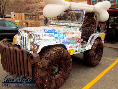
As we zoomed up the road, we found ourselves at Hole in the Rock, which is a 5000 sq ft home carved out of the rock. While we didn’t take the tour, we did walk around the grounds. There’s plenty to see at this “rubber snake shop”. In fact, they had an artfully crafted Jeep sitting outside that appeared to made out of license plates and spare metal.

When we got to Moab, it was cold. Really cold. Remember that fact.

The first order of business in Moab (after lunch) was laundry. We found a laundromat with wi-fi, and while the whirr of machines filled the air, I started looking at the weather. And it yielded some interesting info… there was a massive snowstorm on the way.

After a good clothes cleaning, we traveled to Red Cliffs Lodge. This beautiful place is waaay off the beaten path, about fifteen miles down a canyon, and would be a great place to star watch… if the skies weren’t so cloudy. After watching the news for a while, we decided that if we stuck around, we’d likely not make it back out again. Sadly, this impending winter storm means the end of our vacation travels.

In the morning, we’ll be heading back toward Missouri.

FST II : Day Seven – Down Day

After being treated to another stunning sunrise this morning, Becky and I decided we’d visit the local Navajo arts and crafts market, as well as visiting Goulding’s.

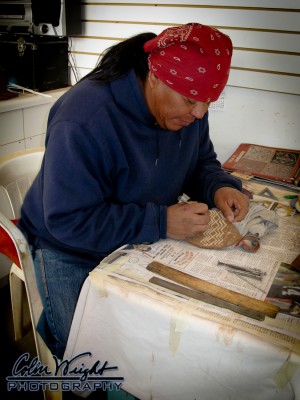
The arts and crafts market was a nice setup. There were four buildings, with about ten separate rooms apiece, each room with its own front door for customers and garage door for loading and unloading. The weather was very cold and windy, so not too many of the artisans were in residence at the arts and crafts market.

We wandered around the open shops, and stumbled upon an artisan, Wilbert “Keeyazhi” Collins, creating carvings in sandstone. He was working on a sandstone piece called “Father Sky” that contained many astronomical elements, making it was impossible for us to avoid picking it up. A few minutes later, he had the finishing touches on the piece, and we took our new object d’art back to the Acadia.

Goulding’s sits across Highway 163 from The View, and has been the lodging for many Hollywood films made in Monument Valley. At the recommendation of Ron yesterday, we ate lunch there. I had a “Navajo Taco”, which was chili along with vegetables, sitting atop a large piece of fry bread. My goodness was that huge!

We took the self-guided tour through the small museum, and saw many photos from film production over the last eight decades or so. We also saw a boatload of photos and stories of the creators of Goulding’s. It was really a nice stop.

There’s an interesting contrast between the two sides of the highway. At The View, the focus is really on the Navajo experience in the valley. At Goulding’s, however, it’s John Wayne and the movie industry that’s memorialized. Much like the whole Native American experience within the US, these two differing views point to a very different view of the land and its use.

FST II : Day Six – A Hike into the Desert

I awoke this morning just before sunrise, and was treated to a view of the desert floor beneath us being lit by the sun as it rose, hidden behind Merrick Butte. This lit the valley floor very selectively, and kept my images from being blown out by the full disc of the sun.

The View has a 17-mile driving trail — the Valley Loop — that can be taken without the aid of a Navajo guide, so Darla and I decided to take a spin through it. It was quite a drive, taking us a few hours to cover the unpaved, rough road. There are about a dozen marked stops along the way, and we took full advantage of them, taking the time to gaze at many of the buttes in the valley floor.

At one of the stops, we met Ron Atine, a Navajo nation member, selling jewelry. We got to talking, and learned that he led tours into the desert to Sand Spring, just across the gulch from where we met him. He told us that he had another couple going with him tonight into the desert, and wondered if we’d be interested. With her knee problems, Darla elected to pass, but I decided to take Ron up on the invitation.

After taking Darla back to the hotel, I drove back down into the valley, and met Ron, helping him breakdown his sales setup so we could get started. Another couple from Europe was there to go along. Ron zoomed down into “proceed only with a guide” roads down into the gulch, and I followed closely behind. The Europeans were having some trouble keeping up, despite them being in a Ford Escape with 4WD. They finally caught up, and we began our march across the sands in the desert.

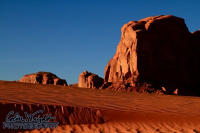
The sandstorm had re-sculpted the dunes, making for the most pristine sands I’ve ever seen. It was simply gorgeous. We walked a ton — and hiking in the sinking sand was tough! — but saw so much beauty in the desert as the sun set. It’s a trip I would definitely do again!

FST II : Day Five – To Monument Valley

Today’s travel changed our locale a grand total of about 45 miles. Given that our checkout time in Bluff and checkin time in Monument Valley were waaaay farther apart than the actual destinations, we had to find something to do for a while. Looking at the map, we decided to visit Canyon de Chelly National Monument.

Canyon de Chelly is a preserved area housing a pair of driving routes on both sides of a canyon concealing ancient ruins. This was a park we’d never been to before, and would’ve been a little off the beaten path were it not for our time-based conundrum. While we got as far as the visitor center, that was about it.

Much like our visit to Steamboat Springs a month ago, the National Park Service decided to reconstruct all the roads leading into the park. Ugh. And like Steamboat, they tried to keep traffic moving in and out of the park. One lane at a time. On freshly laid asphalt. Dodging road construction crews and equipment.

Yeah. That was fun.

The last straw came just after missing being hit by an asphalt hauler and hearing the sound of asphalt pebbles pelting the sides and underbelly of Darla’s new Acadia, we called it quits, and headed to lunch in nearby Chinle AZ. Man, was it windy.

Did I mention it was windy?

Fast forward to the drive toward Monument Valley. With all the wind, we saw loads of tumbleweeds cruising across the road. A couple of ’em were even brave enough (dumb enough) to challenge the mighty Acadia’s authority to the road, and… well… let’s just say that the tumbleweeds didn’t stand a chance. (Sorry if you’re a tumbleweed fan.)

When we arrived at The View, we were greeted to a sandblasting from Mother Nature. The winds were blowing up a terrifically impressive sandstorm, making unloading pretty dang difficult. In fact, we had to brush a bunch of sand out of the Acadia after we were through unloading. It was way sandy inside!

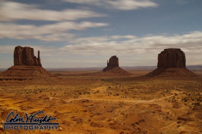
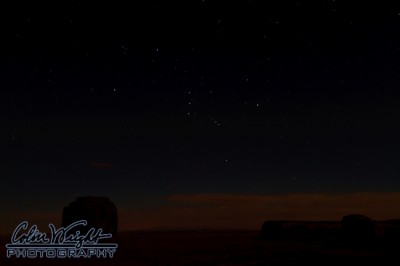
There wasn’t much time after we checked in until sunset, so I dashed out to the balcony, and started firing. It was a beautiful sunset, and a wonderful view from the balcony. This was taken in the dark, with the camera wide open — note Taurus rising among the monuments.

After the glow from sunset was gone, and the sand settled down a bit, we could view the stars more comfortably. My gosh, were they stunning! This is the first chance for me to focus on photographing the night sky with my 7D, and I couldn’t have been more happy. It really captured the essence of the night sky in this beautiful location.

FST II : Day Four – Southern Utah Loop

After a slow start this morning, we decided to make a loop around the area — about 150 miles — visiting Valley of the Gods, Mexican Hat and Natural Bridges National Monument.

Valley of the Gods was billed as a smaller version of Monument Valley, and it lived up to it. Plenty of red rocks catching plenty of sunlight… and clouds, but more on that later. We toured around the area, along a 17 mile road that went from gravel to rutted and back again. Frankly, the Acadia did well with the unimproved road.

However, I had a little less sure footing. Early in the drive, we stopped to take some photos, and I climbed atop a little knoll to grab some images. When I came back down, the rocks shifted, and I tumbled pretty well down the hill. The good news was that I tucked the camera (and my noggin), and rolled pretty well into a three point landing — my left hand, my right knee and my right hip. 🙂 Nothing bad, but some pretty good bumps and bruises. I’ll survive.

Once we were done with Valley of the Gods, we zipped down to Mexican Hat for a little lunch, before heading up the road to Natural Bridges National Monument. To get there, we had to travel across Moki Dugway, which is a crazy unpaved road with tremendous switchbacks, no railing and terrific views. Remember those clouds I mentioned earlier? As we started up the road, the clouds began to produce a little bit of rain, and after turning a corner, we saw a tremendous vista with a wonderful rainbow! It was absolutely stunning. We found a place to pull over, and snapped quite a few images. Way cool.
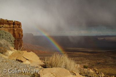
When we got to the top of the hill, we started getting into colder weather, and some rain from the clouds we’d spotted from down in the valley. And then the snow came. Yep, snow. In fact, a snowstorm. The flakes were huge, and coming down with a vengeance. It snowed on us for about 45 minutes, right up to the entrance to Natural Bridges NM.

Natural Bridges was great, and definitely out of the way. In fact, I wouldn’t have been surprised if we were the only people there today. We got our parks passport stamped, and took the nine mile drive through the park. Nice drive, and the bridges were nice to see from the overlooks. In theory, we coulda hiked down to some of them, but with me having already put myself down a hill today, I figured I didn’t need to tempt fate.

From the park, we headed toward Blanding. This was pretty much a big ol’ downhill drive, leading to the base of Comb Ridge. Comb Ridge must run dozens of miles, and was catching the sun just right. We found a place to stop at the base of the ridge, and shot down the length of it. With the fading sunlight, it was simply amazing.
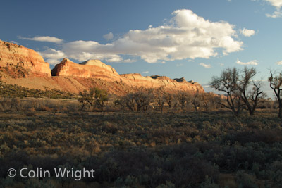
By the time we got back to Bluff, we’d been on the road for almost seven hours, and some of the best photography and weirdest weather I’ve seen in quite some time!
FST II : Day Three – ABQ to Bluff UT

After two days on the interstate system, today’s drive was all state roads… and less. Frankly, I’d rather be on the back roads than on the interstate anyway.

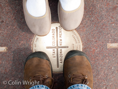
The highlight of today was visiting Four Corners. I’d been wanting to visit this area for a while, and it was worth the wait. I’m kinda a geography geek, so the man-made confluence of four states is pretty irresistible. We took all the geeky pictures — straddling state lines, fingers in all four states — but it’s the photo of our shoes that I liked best.

And in the “we’re not in Kansas anymore” department… we just saw a commercial for a clothier from somewhere here in Utah, who apparently is focusing on making the well-dressed teenaged Mormon missionary. Talk about a specialized market!!!!

FST II : Day Two – OKC to ABQ

This morning found us pulling out of Oklahoma City in some cold weather. With the front through the area, it was in the low 30s when we pointed the Acadia westward.

As we got closer to Amarillo, we began to see signs of yesterday’s snow. From what we heard, they got about four inches, which is somewhat unusual for them during this time of the year. With snow on the ground, we had to stop at the Cadillac Ranch. Ordinarily, we would’ve gone down to the Caddies, but the snow had been melting all morning, and the path was miserably sloppy. We didn’t even try to get down there. Still, it was beautiful to see the fields with snow still dusting them.

FST II : Day One – STL to OKC

Falling Star Trek II got underway today with the first leg of our journey — St. Louis to Oklahoma City. As I’ve noted before, the first day or so out of STL is always uneventful — it’s just a slight terrain transition that we see in the first 500 miles or so.

Today, though, we knew we would be in for some pretty fierce weather as we traveled toward Oklahoma. There was a huge front between STL and OKC, and looked to be pretty interesting. In fact, Amarillo (which we’ll pass through tomorrow) was supposed to be getting snow. As we got close to Oklahoma City, we got blown all over the place by some tremendous storms. The rain was so fierce that you couldn’t see thirty feet in front of you. Wild stuff.

Tomorrow — we journey to Albuquerque!